Twisters carve destructive path through the Texas Panhandle
At least five tornadoes—and likely more, as-yet undocumented—spun through the Texas Panhandle last Thursday, May 23. The fiercest was a wedge-shaped beast—more than a half-mile wide—that touched down northwest of Canadian early Thursday evening, and carved a nearly 17-mile path on the ground.
That twister originated south-southwest of Wolf Creek Park in Roberts County, crossing US 83 and tracking northeast into Lipscomb County, giving storm chasers plenty of photo ops along the way. At its peak, the tornado’s wind speed was estimated at 115 mph. It snapped power poles and downed power lines, flattened fence rows, stripped and delimbed trees, and left a trail of dead and severely injured cattle.
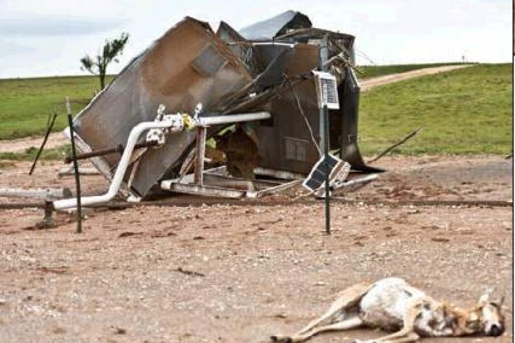
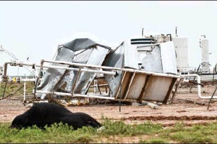
A farmhouse on FM 281 was spared, taking only a glancing blow from the edge of the tornado. But on the other side of US 83, about 3.5 miles north on the Booker highway, a FourPoint Energy location took a direct hit. The funnel mangled oilfield equipment and storage tanks, and left behind the carcasses of a pronghorn antelope and steer.
According to a public information statement issued by Amarillo’s National Weather Service, there were numerous supercells across the Texas and Oklahoma panhandles on the 23rd, with some producing brief tornados and landspouts.
Two supercells produced tornadoes that were seen by storm chasers, the report said, with one touching down in Roberts County and ending in Lipscomb County, and the other starting in Lipscomb and ending in Beaver County across the Oklahoma line. Both were large tornadoes, causing damage that rated an EF-2.
Three other tornadoes were documented, said Warning Coordination Meteorologist Mike Gittinger, “but I would not be shocked to find more.”
Gittinger visited the area Friday to assess the damage and rate the tornado’s strength. Though he rated it an EF-2, in reality, he said, it was probably stronger.
“We rate these things on a damage scale, based on what we see,” Gittinger said. “The problem is, it’s hard to know on some of the damage to oilfield equipment, and how those tanks were pushed around. There are no real studies on what that might mean.”
Gittinger explained that most windspeed studies are done on more common thingsfor example, houses and buildings. What he saw Friday, and in the videos documenting the tornado that he is still reviewing, was impressive, he said, “but I don’t know what that means for windspeed.”
The other problem, he admitted, is that his office is still catching up from several days of severe weather events.
Asked what conditions contributed to the outbreak, he said, “It has to do with having a lot of wind sheer—a lot of rapid turning in winds, increasing in speed with height, with 60 mph winds at 4,000-5,000 feet.”
Those strong upper-level winds displace updraft from downdraft, creating a vacuum effect at the top that helps sustain the storm’s intensity. Add to that mix the abundant moisture that the Panhandle has seen, he said. “To get these organized storms, we have to have late spring upper-level pressure systems to bring it all together. Moisture, instability, and storms. That’s why they hit.”
There was moisture aplenty, too. According to Hemphill County Underground Water District employee Carolyn Price, records show that southeast Hemphill County has seen 8.23 inches of rain this month alone, while the southwestern quadrant has recorded a still-generous 4.66 inches. Glazier gauges have collected 6.06 inches this month-todate, and 6 miles east of Canadian, 5.37 inches has fallen.
According to Elsie Kelln, one rancher northeast of town measured 4 inches of rain at his place on Thursday. Kelln also heard reports of a pump jack being picked up by the tornado—sucker rod and all—on the Booker highway (SH 23).
A home owned by John and Ilene Floyd, along that highway, was buried in tree limbs by the same vortex that struck the FourPoint site. Jimmy Burt, who lives there, said a fourhorse trailer outside the home was pointed north, and the twister turned it around, planted it south, and drove it into the barn, punching a hole in the structure’s wall.
“It picked up a storage building, too,” said Ilene Floyd. “It must have gone pretty high in the air, because it took it over an older building and a tree, then dumped it out south of there, about 30 to 40-feet away. The stuff inside it rode for a while, then fell out.”
“Jimmy got there about dusk, after it was over,” she said. “Some of the building was on the pasture fence, and he was trying to get it off, but his hands kept getting sticky.”
Burt couldn’t figure out why until he got into the light, and realized his hands were covered with sticky red paint, that had marked a trail through the pasture.”
Eddie Longhofer, who owns land just to the south, lost miles of fence and several steers. “He lost 10 to 12 outright,” Ilene said, “and had to shoot quite a few others.”
Another neighbor—91-year-old Fred Hale—lives about about 3-4 miles away as the crow flies, she said. “He went to his back door to look out,” Ilene said, “and it jerked the door out of his hand, and tore it off the hinges, before blowing him back into the house.”
Hale’s house was fine, but nearby, the tornado blew down miles of power poles and fencing, and left debris everywhere.
Others were less fortunate. Two manufactured homes being transported by truck were blown off US 83, north of Canadian—a moment captured in YouTube history by storm chasers, as they debated whether or not it was time to depart the area.


